Road Congestion — Real-time
█████ Zhongshan Rd (E) 92%
████▓ Nanjing Rd 87%
███▓░ Huaihai Rd 68%
██▓░░ Yan'an Elevated 54%
▓░░░░ Pudong Ave 23%
░░░░░ Outer Ring Rd 12%
Avg speed 18.4 km/h (congested)
Incidents 3 active | 7 minor
Est. clear Zhongshan Rd ~25min
Junction Flow — Top 5
J-0421 Zhongshan×Xizang 1820 veh/h
J-0107 Nanjing×Henan 1650 veh/h
J-0338 Huaihai×Hengshan 1380 veh/h
J-0712 Yan'an×Huashan 1120 veh/h
J-0205 Pudong×Lujiazui 680 veh/h
Signal cycles 142 active
Queue length max 480m @ J-0421
Wait time avg 3m20s
Highway Real-time Status
G2 Beijing–Shanghai Smooth 98 km/h
G15 Shenyang–Haikou Slow 42 km/h
G50 Shanghai–ChongqingBlocked 12 km/h
G60 Shanghai–Kunming Smooth 102 km/h
S20 Outer Ring Heavy 35 km/h
S5 Humin Elevated Jam 8 km/h
Toll stations 47 open | 3 restricted
ETC pass rate 94.2%
Incident G50 Truck breakdown km 32+800
Highway Camera Feed
CAM-G2-018 km 45+200 ●LIVE 3 lanes clear
CAM-G15-042 km 78+500 ●LIVE heavy flow
CAM-G50-031 km 32+800 ●LIVE incident zone
CAM-G50-032 km 33+100 ●LIVE queue 2.1km
CAM-G60-027 km 52+000 ●LIVE 3 lanes clear
CAM-S5-014 km 12+300 ●LIVE congested
VMS boards 128 active
Advisory G50 divert → S20
Tow dispatched en route to G50
Traffic Signal Status
Normal 1,842 / 1,860
Adjusting 12
Fault 6
J-0421 Phase: N-S Green 42s → E-W Red
J-0107 Phase: All Red 3s → N-S Green next
J-0338 Phase: E-W Green 28s → N-S Red
J-0712 Phase: N-S Green 55s (extended +15s)
J-0205 Phase: E-W Green 20s → N-S Green
Adaptive AI ACTIVE — 428 junctions
Fault J-0512 Lamp R2 offline — dispatch sent
Signal Coordination — Green Wave
Corridor A Zhongshan Rd Green wave ON 45 km/h
Corridor B Huaihai Rd Green wave ON 40 km/h
Corridor C Pudong Ave Green wave ON 50 km/h
Corridor D Yan'an Elevated Suspended incident
Sync rate 96.7%
Avg delay 14.2s/junction -22% vs fixed
Cycles today 18,420
Auto-tune 312 adjustments/hr
Traffic Heat Map — City Grid


░ Low ▓ Medium █ High
Hot zones 3 critical | 8 elevated
Peak area Zhongshan×Xizang grid
Heat Map Analytics
City index 6.8 / 10
Congested 23.4%
Smooth 68.2%
Vehicles 847,231 live tracking
Trend (1h) ▲ +12% congestion
Forecast Peak in 25min
AI prediction94.2% accuracy
Suggestion Divert → Outer Ring
Police Dispatch — Congestion Relief
DISPATCH Unit-TP-018 → Zhongshan Rd (E)
ETA 3min | Distance 1.2km | Status: en route
DISPATCH Unit-TP-032 → Nanjing Rd
ETA 5min | Distance 2.8km | Status: en route
DISPATCH Unit-TP-007 → G50 km 32+800
ETA 8min | Distance 5.1km | Status: en route
RESOLVED Unit-TP-021 @ Huaihai Rd
Cleared in 6min | Traffic恢复 normal
Active units 18 deployed | 6 standby
Avg response 4m 12s
Drone support 2 airborne — aerial view
Dispatch Map — Units
TP-018 ▶ moving N → S 38 km/h
TP-032 ▶ moving E → W 42 km/h
TP-007 ▶ moving S → N 55 km/h
TP-021 ● on-site clearing
TP-045 ◆ standby HQ
TP-067 ◆ standby HQ
DRN-01 ▲ airborne alt 120m
DRN-02 ▲ airborne alt 150m
Coverage 14/16 zones active
Traffic Violations — Live Capture
VIOLATION CAM-V-1042 | SPEEDING
沪A·8F2K9 | 98 km/h (limit 60) | Zhongshan Rd
VIOLATION CAM-V-1078 | RED LIGHT
沪B·3M7X2 | Ran red 3.2s after | Nanjing×Henan
VIOLATION CAM-V-1105 | LANE CROSS
沪C·9K4L7 | Solid line crossing | Huaihai Rd
VIOLATION CAM-V-1121 | SPEEDING
苏E·2H8N3 | 112 km/h (limit 80) | G50 km 28
VIOLATION CAM-V-1138 | REVERSE
沪A·5T1Q8 | Wrong-way driving | Yan'an Elevated
Today total 1,847 | Avg/hr 77
Auto-citation 94.3% confirmed
Violation Breakdown — Today
Speeding 842
Red light 431
Lane cross 298
Illegal park 156
No seatbelt 82
Phone use 38
Hotspot Zhongshan Rd (E) 186
Peak hour 17:00–18:00
AI accuracy97.8% plate recognition
Intelligent Transportation Systems

Smart Traffic Solutions

Three integrated platforms — Traffic Big Data, Traffic Flow, and Traffic Violation — for data-driven urban traffic management.

Traffic Big Data Intelligent Analysis Platform

Data-driven scientific governance for urban traffic management.

The Traffic Big Data System is an intelligent analysis platform developed based on big data technology. By integrating multi-source information from urban traffic — vehicles, passing vehicle records, and traffic flow — it performs multi-dimensional data mining and correlation analysis to construct a city traffic network model, providing police with data query services, vehicle big data analysis, and real-time traffic flow analysis.

Through a data-driven scientific governance model, it drives the transformation of urban traffic management from experience-based decision-making to data-based decision-making, providing core support for building a safe, efficient, and green urban transportation system.

01 — Product Features

Passing Vehicle Query

All passing vehicle data centralized on one page. Historical vehicle capture records retrievable by license plate features, vehicle characteristics, passing time, and location.
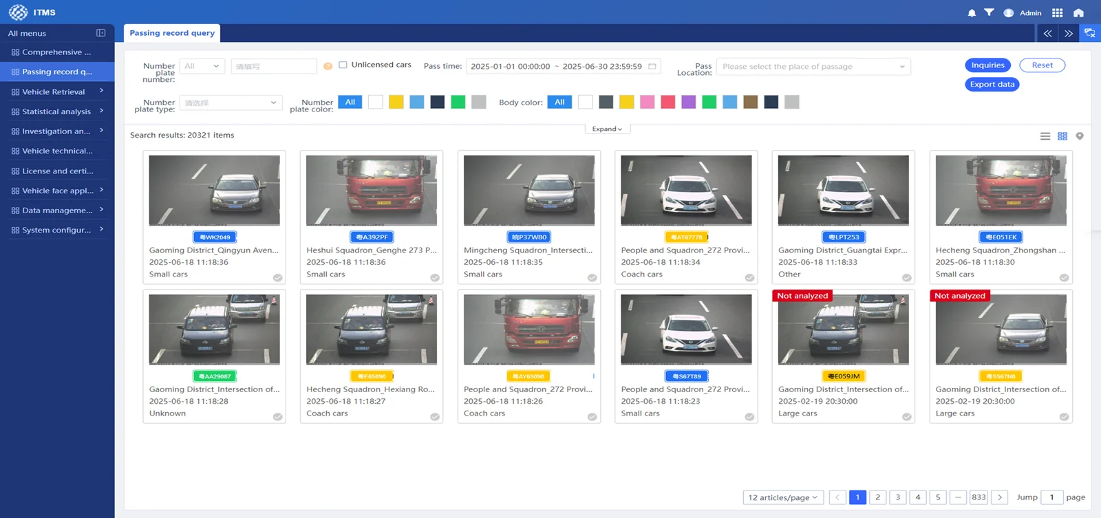
Passing Vehicle Query Interface

Traffic Flow Statistical Analysis

Analyze traffic flow within a specified time range by dimensions such as location, vehicle type, license plate color, and license plate type.
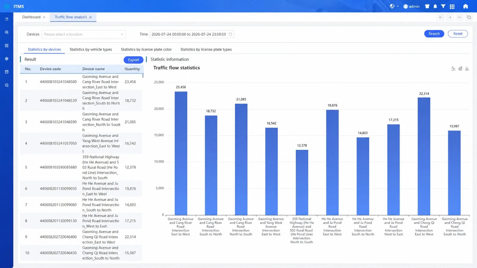
Traffic Flow Statistical Analysis Dashboard

Vehicle Tactical Analysis

Filters and screens massive vehicle data based on searched vehicle characteristic details, incorporating practical investigation techniques to assist officers with reference data for decision-making.
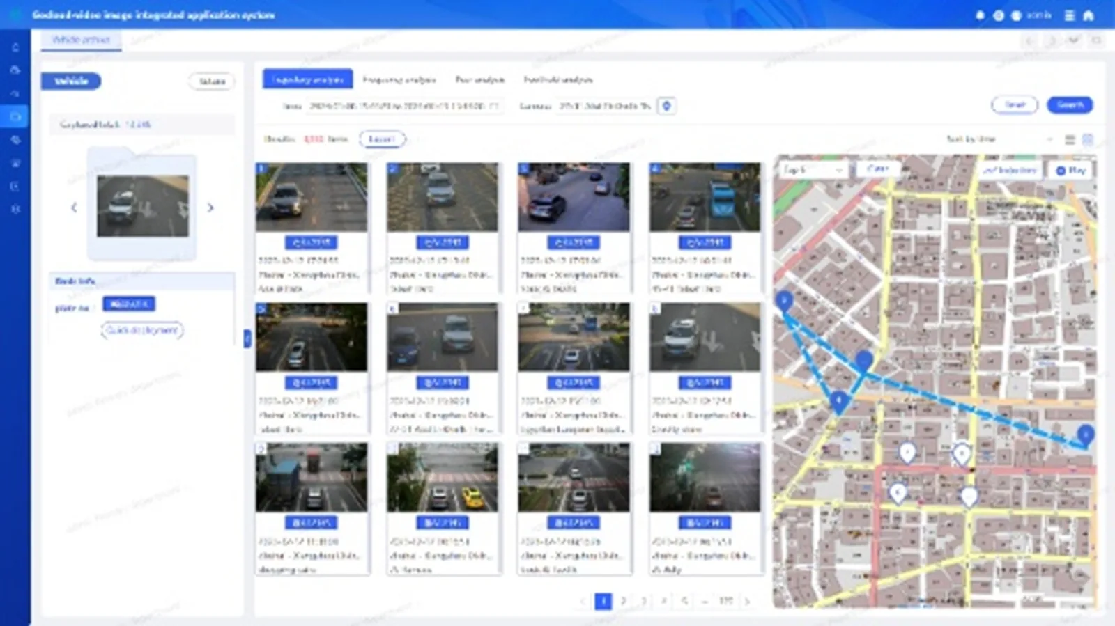
Vehicle Tactical Analysis Interface

Investigation and Control

Supports deployment, revocation, and alert management for suspicious vehicles. Real-time deployment triggers alerts and pushes notifications when illegal vehicles are detected.
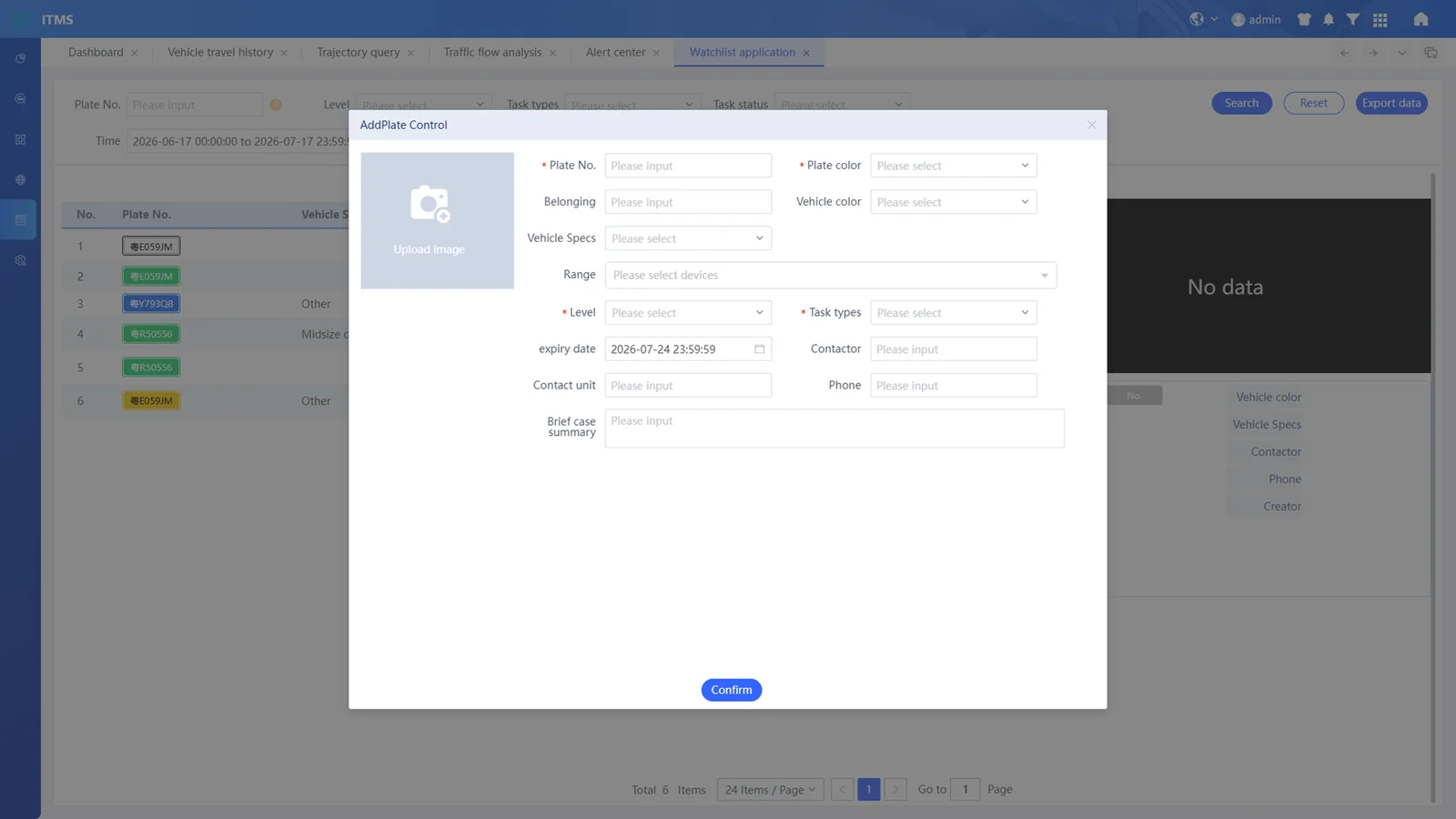
Investigation and Control Interface
02 — Algorithm Types
20+
Vehicle Algorithms
12
Motorcycle Algorithms
2
Algorithm Categories
30+
Total Recognition Types
Vehicle Algorithms 20+
License Plate Body Color Vehicle Type Brand Series Plate TypePlate Color Driver SeatbeltPassenger Seatbelt Driver CallingDriver Smoking Inspection StickerPlate Covering MoonroofTissue Box Sun VisorNo Plate OrnamentHanging Ornament License Plate ObscurationSpecial Vehicle
Motorcycle Algorithms 12
Body Color Vehicle TypeHelmet On Driving DirectionWith Canopy Running StatusMultiple Riders Front BasketRear Trunk Rearview MirrorsTwo Persons with Helmets Upper Body Color
03 — Advanced Features

Multi-Plate Recognition

Capable of quickly recognizing multiple license plates from high-definition images.

Unlicensed Vehicle Capture

The checkpoint function detects and records unlicensed vehicles passing through the intersection.

Diverse Plate Type Support

Supports recognition of various plate types including civilian plates, non-motor vehicle plates, and other categories.

Resume Transmission

In network failures, data and images are stored locally. Once resolved, the system automatically uploads to the traffic management data center.

Data Intelligence & Analysis

Backend software provides GIS-based information visualization, cloned vehicle management, vehicle association analysis, and other advanced functions.

High Performance

Multi-threading significantly improves data read/write performance. Achieves second-level query response across tens of billions of records — dozens of times faster than traditional databases.

System Architecture
Traffic Big Data — System Architecture Topology
L1 · Application Layer
Business Applications
Vehicle Basic Traffic Big Data Statistical Analysis
L2 · Analysis Layer
View Parsing Platform
License Plate Recognition Vehicle Recognition
L3 · Access Layer
Data Ingestion
Extraction Joining Cleaning Distribution
Stream Storage
Video Stream Image Stream Vehicle DB
L4 · Data Layer
Computing Infrastructure
IVS 3800 OceanStor ARM/Atlas X86/74
Edge Devices
Capture Camera Structured Camera Private Network

Traffic Flow Information Collection System

Real-time traffic flow monitoring, analysis, and visualization.

The traffic flow information collection system collects raw traffic flow data — traffic volume, vehicle speed, occupancy rate, vehicle length, and inter-vehicle distance — through various methods including front-end ground induction coil detection, video detection, and microwave detection. It integrates and statistically analyzes the collected data, transmitting it to the command center via transmission network.

01 — Product Features

Traffic Flow Data Collection

Real-time traffic display using different colors to distinguish congestion levels. Shows congestion index, congestion mileage proportion, and predicted congestion situation across the entire road network.
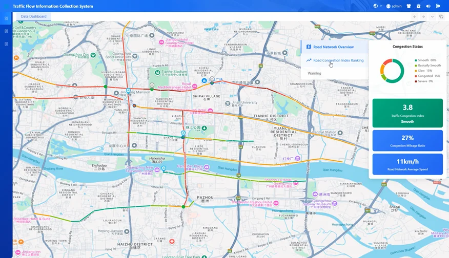
Traffic Flow Data Collection

Road Network Overview

Centralized display of road network information with real-time road conditions, congestion status, and comprehensive traffic overview across all monitored segments.
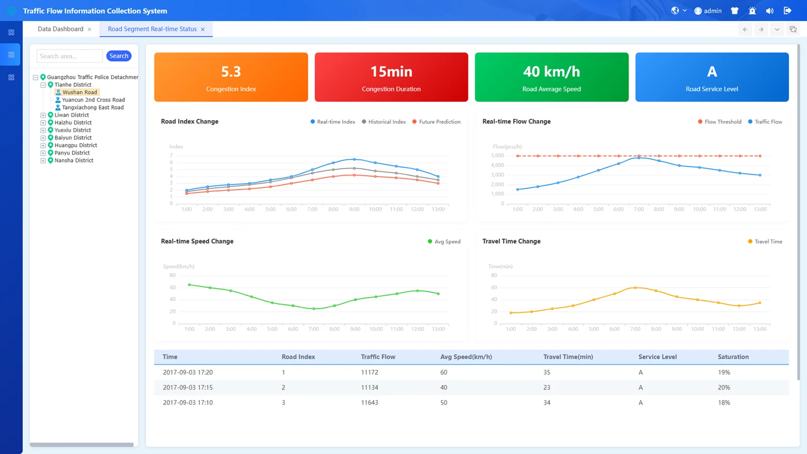
Road Network Overview

Comparative Data Analysis

Analyze traffic flow during different time periods, including morning and evening rush hours. Grasp patterns of traffic flow changes and predict trends during specific time intervals.
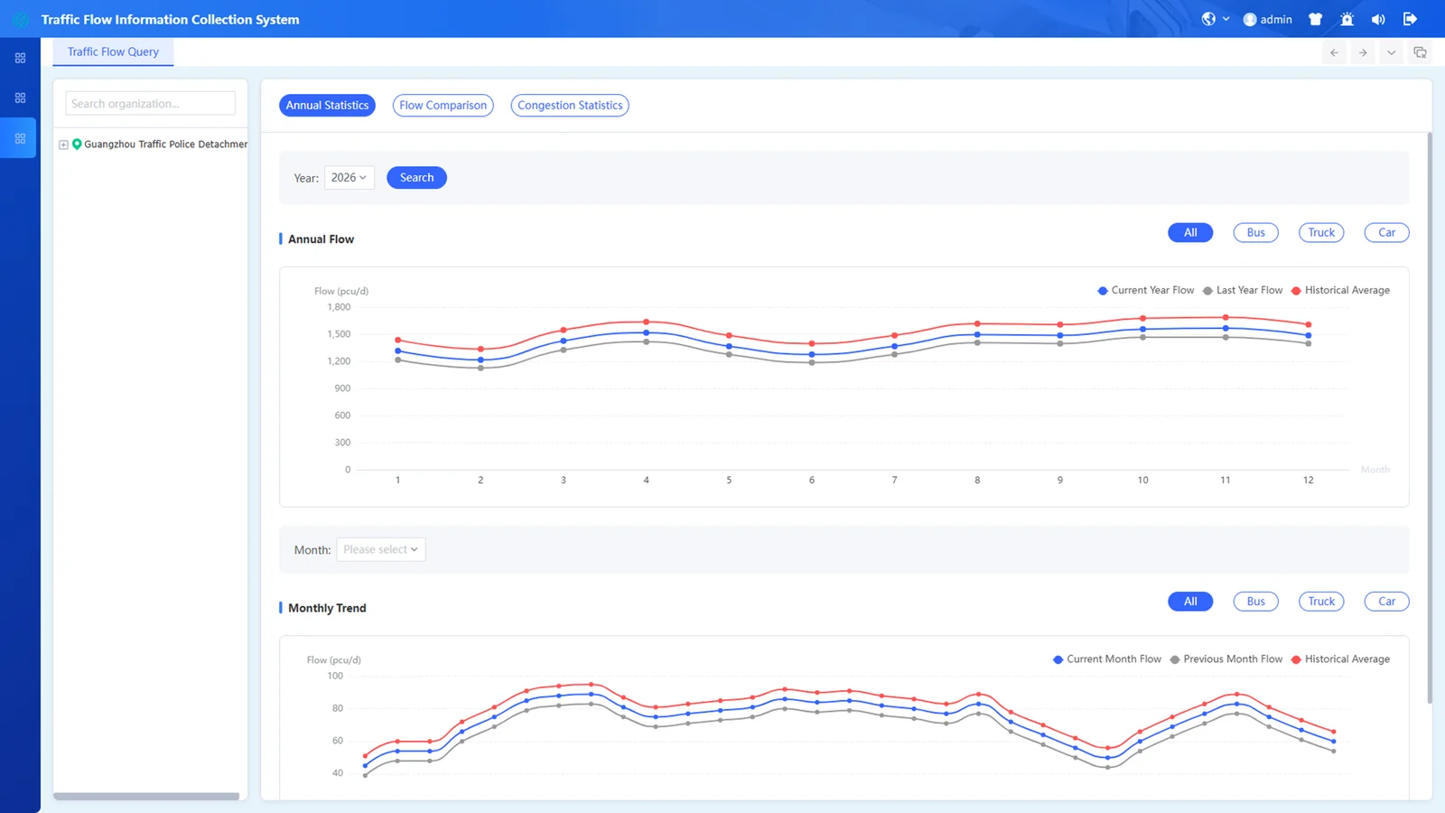
Comparative Data Analysis

Traffic Flow Heat Map

Intuitively display traffic flow density distribution as a heat map. Highlights the top 5 road sections with highest flow, facilitating rapid identification of traffic hotspots and congestion nodes.
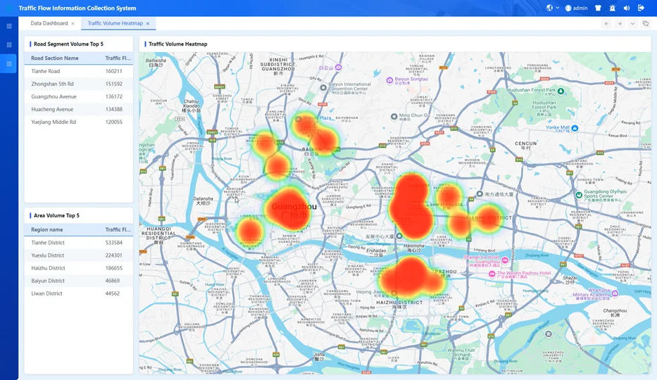
Traffic Flow Heat Map
02 — System Characteristics

Traffic Flow Data Collection

Traffic volume, average vehicle speed, average headway, average time headway, occupancy rate of each lane.

Data Comparison

Comparative analysis of real-time traffic flow data and historical data for trend identification.

Data Application

Provides rich traffic data services for command and dispatch, third-party platforms, and assists management departments in decision-making.

Dynamic Display

Data presented in tables, fitted curves, graphics, electronic map distributions, and other dynamic formats.

03 — Overall Architecture
Traffic Flow — Architecture Topology
L1 · Application
Traffic Applications
Road Overview Real-time Conditions OD Analysis Flow Report Congestion Query
L2 · Storage
Data Resource Management
Resource Library Info Service Processing Model Standards
L3 · Network
Transmission
Dedicated Network Security Boundary Access Platform
L4 · Collection
Sensor Detection
Loop Detector Video Magnetometer Radar Infrared
Vehicle Systems
Mobile Patrol RFID E-police Toll System GPS

Traffic Violation Processing System

Intelligent violation detection, capture, and enforcement platform.

The Traffic Violation Processing Subsystem is deployed on major traffic arteries at city entry and exit points. Leveraging advanced optoelectronics, computing, violation capture devices, and remote data access, it collects violation information, performs pre-processing and review, uploads confirmed records to the higher-level platform, and provides multi-angle statistical analysis.

System Modules
Violation Record Query
Violation Statistics
Intersection Violation Ranking
Continuous Violation Analysis
Violation Device Monitoring
Upload Data Statistics
Successful Upload Query
Failed Upload Query
01 — Product Features

Data Dashboard

Aggregates violation data from front-end devices. Displays device-captured data on a map, top 10 devices by violation count in bar chart, today's statistics, 24-hour distribution, and violation trend chart.
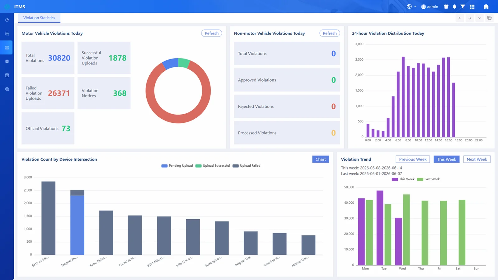
Data Dashboard

Violation Record Query

Centralized query of all violation records. Search by license plate, violation time. List or thumbnail view with detail access. Export to Excel, export images, or Excel with images.
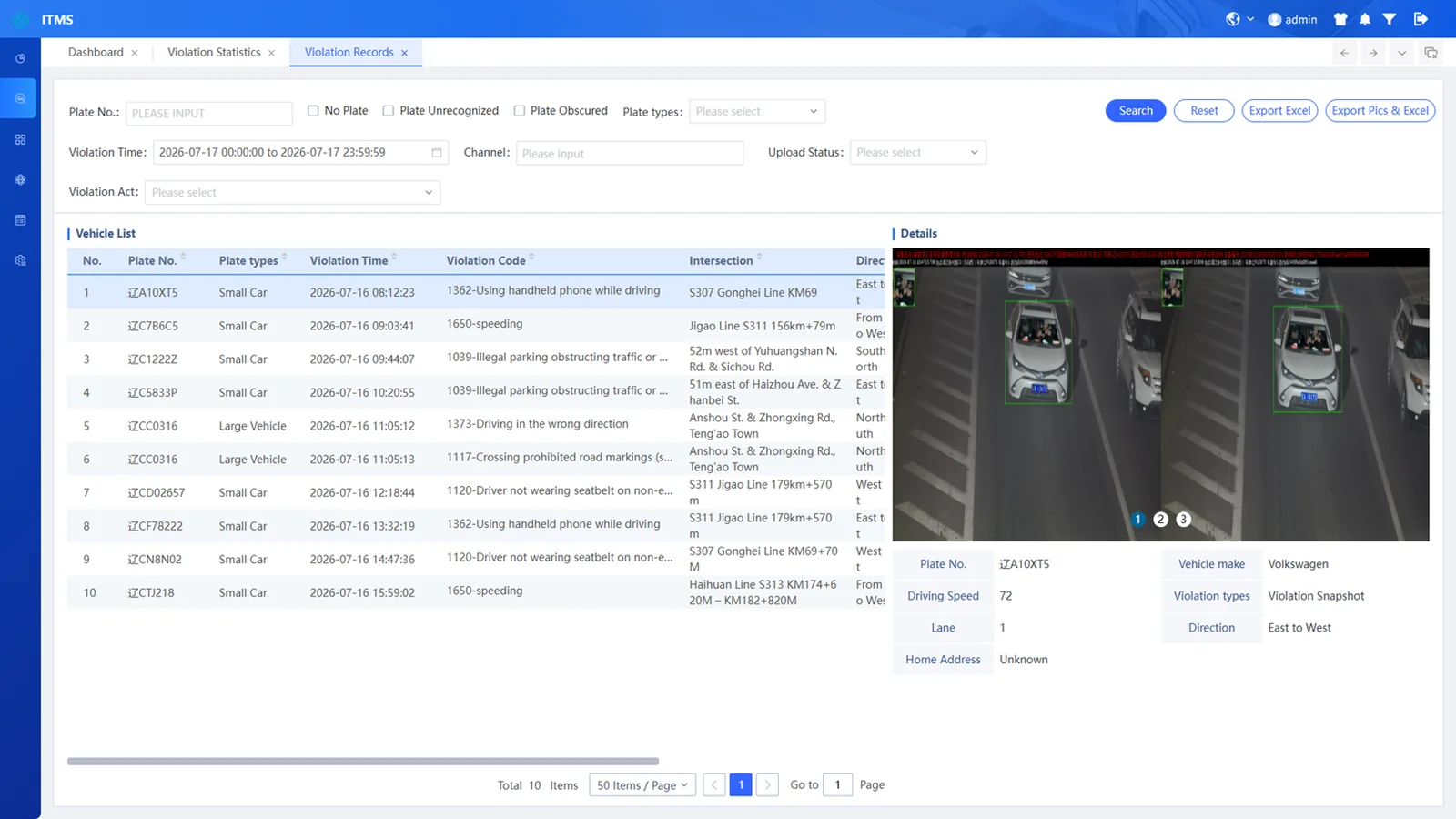
Violation Record Query
02 — Product Features (Continued)

Manual Entry

Supports manual input of violation data and accepts images captured by various devices.

License Plate Recognition

Quickly recognizes license plates from high-definition images with high accuracy.

Resume Transmission

In network failures, data and images are stored at roadside front-end. Once resolved, automatically uploads to the traffic management data center.

High Performance

Multi-threading improves data write and read performance. Sub-second query response across tens of billions of records — dozens of times faster than traditional databases.

High Reliability
Decentralized Design
No Single Point of Failure
The massive-data support platform adopts a decentralized design ensuring overall high reliability of the system.
03 — Overall Architecture
Traffic Violation — Architecture Topology
L1 · Application
Violation Applications
Record Query Behavior Statistics Segment Ranking Device Monitoring Upload Stats
L2 · Analysis
Visual Analytics
License Plate Recognition Violation Behavior Recognition
L3 · Access Layer
Data Ingestion & Processing
Image Stream Ingestion Data Association Data Retrieval Data Upload
L4 · Infrastructure
Computing & Storage
ARM Server X86 Server IVS 3800 OceanStor Private Network
Enforcement Device Types
E-police
Illegal Parking Camera
Speed Detection Camera
Pedestrian Violation Camera
Vehicle Ban Enforcement
More Devices
Security
Data Security

Comprehensive data protection across all layers

Video Security

Encrypted video stream protection